 |
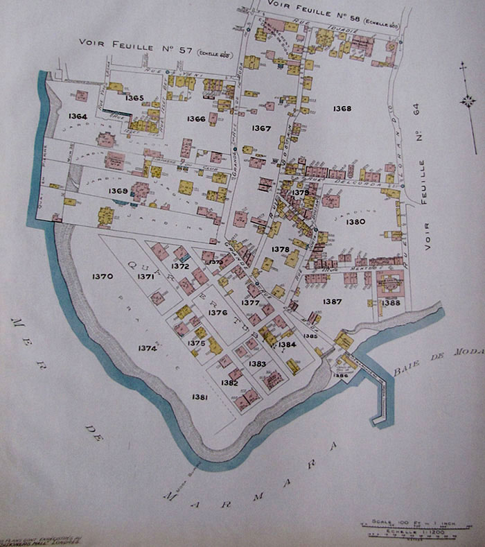
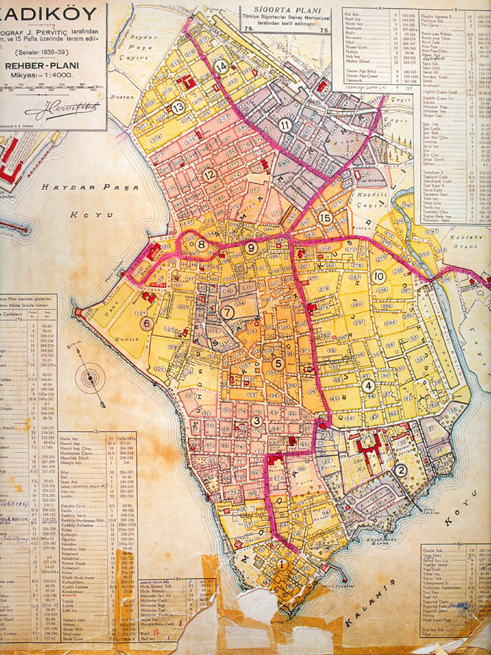
Taken from the beautiful, huge folio of Istanbul maps (Goad map of 1906) that have recently been published in Istanbul, this one in the series highlighting Kadıköy. So this map explains ‘Quai Tubini’. It could have been owned by the Tubinis, or just located in the ‘Quartier Tubini’, clearly they were people of some local influence.
Additional information courtesy of Betty McKernan, 2010:
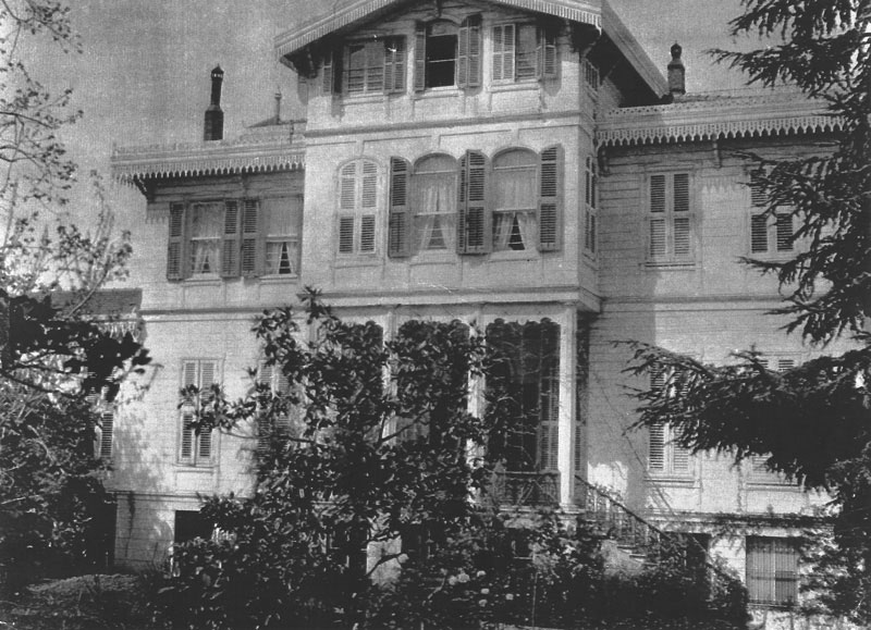
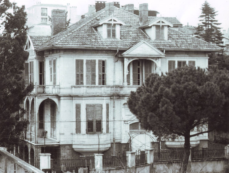
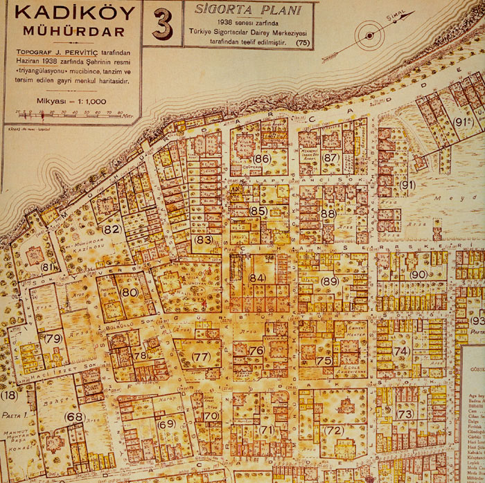
Jacques Pervititch’s 1938-39 map below shows Frederick Edwin Whittall’s property very clearly and the two little red squares at the end of the property by Moda Caddesi were one being the stables later converted into living accommodation and the other the building which was occupied by Herakli and his family, who looked after just about everything.
I suspect that Sir James Whittall’s house might have been adjacent to Frederick Edwin’s. When I was growing up, down Vitol Çıkmazı on the right, from Moda Caddesi towards the sea, was Dick and Daisy La Fontaine’s house, then there was William James Harter & Lilian Whittall’s (Yolande Whittall’s granny) house - I believe they are the two yellow houses in the Goad map, reference 1369. Closer to the sea (probably just to the right of the reference 1369, there was a large red brick house in which Robert G. Lawson and his family lived (wife Aileen, sons Duncan, Roderick and Robert). Bob Lawson was the General Manager of Santral Dikiş Sanayii, which was the Turkish Branch of Coates, the thread manufacturers in Scotland. It was a Scottish family. This red brick house was on a level with Frederick Edwin’s house, separated by a brick wall (I know, because the boys would scale it to come into the Frederick Edwin’s garden when my sister and I spent the summers there - we were of an age.
hover below for archive views of the properties of:
Going back to Moda Çıkmazı, there is only a little more that I can add. Just after Twee Cottage in the direction of the sea was a reasonably palatial building, not terribly tall - three floors maximum, painted yellow. This was the home of Sevket Keçeci and his son Ali. Where Twee Cottage stood, there is now a block of flats, and I believe that yellow building still stands in front of the block of flats. My sister was the supplier of these names. I cannot remember any Club de Moda down Moda Çıkmazı, although I do remember that half way down Moda Çıkmazı on the right had side there was a large set of gates which were never opened. There was a large building behind it, but I never questioned what it was - what child does? My grandparents did move to 5 Yusuf Kamil Pasa Sokak when they were forced to leave Twee Cottage.
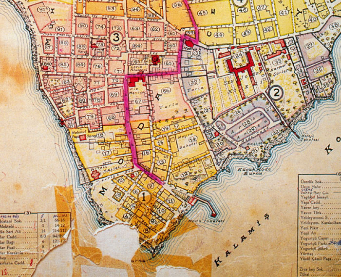
Looking back at the Goad map again, reference 1387, you will notice 4 buildings at the beginning of Mektep Sokak, on the “south side” as you look at the map. In the second of those houses lived Eddie and Eileen La Fontaine and in the fourth lived Kenneth Edwin La Fontaine Whittall. On the same map, reference 1384, there appear to be 3 yellow dwellings - if I am correct, the middle one was the residence of Kenrick Edward Whittall and his Russian wife, Alexandra Boscovitch. And the last one I remember is down Devriye Sokak, ref 1373, I believe the house nearest to Devriye sokak was occupied by Reginald La Fontaine Whittall and his wife Gwendoline Barfield.
Finally returning to the detailed Jacques Pervititch map, just above reference 16, there is a plot that looks unbuilt upon, then two smaller ones with a house each and then a larger plot with one house close to the road. I think that was the Pavlantos house. They were Greek - I cannot remember their names as we called them “Old Mr Pavlantos and Mrs Pavlantos”. They had two children, John amd Marika. Marika was married to a chap called Socratis and he ran a car spare parts shop in Taksim. I think they may have gone to live in Greece eventually. The son John, was married to Claudia - they emigrated to the US.
Additional information courtesy of Betty McKernan, 2010:
Jacques Pervititch’s 1938-39 map below shows Frederick Edwin Whittall’s property very clearly and the two little red squares at the end of the property by Moda Caddesi were one being the stables later converted into living accommodation and the other the building which was occupied by Herakli and his family, who looked after just about everything.
I suspect that Sir James Whittall’s house might have been adjacent to Frederick Edwin’s. When I was growing up, down Vitol Çıkmazı on the right, from Moda Caddesi towards the sea, was Dick and Daisy La Fontaine’s house, then there was William James Harter & Lilian Whittall’s (Yolande Whittall’s granny) house - I believe they are the two yellow houses in the Goad map, reference 1369. Closer to the sea (probably just to the right of the reference 1369, there was a large red brick house in which Robert G. Lawson and his family lived (wife Aileen, sons Duncan, Roderick and Robert). Bob Lawson was the General Manager of Santral Dikiş Sanayii, which was the Turkish Branch of Coates, the thread manufacturers in Scotland. It was a Scottish family. This red brick house was on a level with Frederick Edwin’s house, separated by a brick wall (I know, because the boys would scale it to come into the Frederick Edwin’s garden when my sister and I spent the summers there - we were of an age.
hover below for archive views of the properties of:
Going back to Moda Çıkmazı, there is only a little more that I can add. Just after Twee Cottage in the direction of the sea was a reasonably palatial building, not terribly tall - three floors maximum, painted yellow. This was the home of Sevket Keçeci and his son Ali. Where Twee Cottage stood, there is now a block of flats, and I believe that yellow building still stands in front of the block of flats. My sister was the supplier of these names. I cannot remember any Club de Moda down Moda Çıkmazı, although I do remember that half way down Moda Çıkmazı on the right had side there was a large set of gates which were never opened. There was a large building behind it, but I never questioned what it was - what child does? My grandparents did move to 5 Yusuf Kamil Pasa Sokak when they were forced to leave Twee Cottage.
Looking back at the Goad map again, reference 1387, you will notice 4 buildings at the beginning of Mektep Sokak, on the “south side” as you look at the map. In the second of those houses lived Eddie and Eileen La Fontaine and in the fourth lived Kenneth Edwin La Fontaine Whittall. On the same map, reference 1384, there appear to be 3 yellow dwellings - if I am correct, the middle one was the residence of Kenrick Edward Whittall and his Russian wife, Alexandra Boscovitch. And the last one I remember is down Devriye Sokak, ref 1373, I believe the house nearest to Devriye sokak was occupied by Reginald La Fontaine Whittall and his wife Gwendoline Barfield.
Finally returning to the detailed Jacques Pervititch map, just above reference 16, there is a plot that looks unbuilt upon, then two smaller ones with a house each and then a larger plot with one house close to the road. I think that was the Pavlantos house. They were Greek - I cannot remember their names as we called them “Old Mr Pavlantos and Mrs Pavlantos”. They had two children, John amd Marika. Marika was married to a chap called Socratis and he ran a car spare parts shop in Taksim. I think they may have gone to live in Greece eventually. The son John, was married to Claudia - they emigrated to the US.
 |
Jacques Pervititch’s map for his 1938-1939 Kadıköy series.
 |
Zoom into the base region of this map and ‘Whitall Yalısı’ is visible: F. Edwin Whittall House.
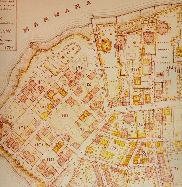 |
Higher resolution map done at the same by Pervititch again, zone 1 equating to the Southern end of Moda penunsula.
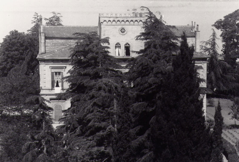
- The house marked Mahmud Muhtar Pasa Konagi on Pervititch/1938/Moda/sheet 1 is the surviving marble mansion of Mahmud Muhtar Pasha and his wife Princess Nimetullah Ismail of Egypt, now used as a girls’ school; its impressive gates, numbered 248 Moda Caddesi on the 1938 map, also survive. The house appears to have belonged to Mahmud Muhtar’s family from 1897 until the 1950s (Muhtar Pasha died in 1935, Princess Nimetullah in 1945).
- The house named Morali Ali Zade Bey in 1938 is described as “Lycée Français Faure” on the 1906 Goad map and “Cimcoz” on Yolande Whittall’s photo of the area taken from the sea. The Morali family was related to the Ottoman and Egyptian royal families, and descendants appear to have owned the house into the 1950s and beyond. The Morali family was also related to the Cimcoz family. This house has been replaced with an apartment block.
- The lane called Moda Cıkmazı is called “Impasse du Club” on the 1906 Goad map. The 1906 map shows a narrow building, just to the north of “Twee Cottage”, called “Club de Moda”, hence “Impasse du Club”. The building was gone by 1938 and the current name of this lane is Belkis Dilligil Sokak.
- All of the main Whittall houses are clearly marked and their street numbers are visible on the 1938 map. It is interesting that the house (area 17 on map) of Sir James Whittall (d. 1910) was already a “harap” (ruin) in 1938. The building under construction in 1937, to the left of the ruin, is probably the still-extant Lawson house mentioned by Betty McKernan.
- The house (area 16 on map) marked Akif Pasa Konağı at 231/233 Moda Caddesi is the still-extant stone mansion of Arif (not Akif) Pasha, designed by the Ottoman Greek architect Konstantinos Pappas. This house, and the wooden house now used as a bank, set well back from Moda Caddesi at number 217 (on Pervititch/1938/Moda/sheet 3 - also visible on the Google Earth map) are the only old buildings surviving on this side of the street.
- The former James F. L. Whittall house at number 5 Yusuf Kamil Paşa Sokak, roughly across from the English Church (marked as “Temple”, bottom right corner of visible map), is also visible, as is its semi-detached neighbour, the latter now replaced with a highrise.
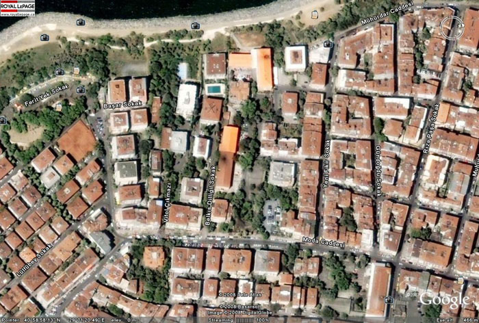 |
Google Earth 2008 of Moda, showing the current names of streets in the neighborhood of the Whittall compound.
 |
Pervititch map sheet 3 of the neighbouring zone, extending North, still in Moda. The former (Gaby) Couteaux mansion is visible in zone 86. The descendants of this wealthy Belgian industrialist still live in the city.
 |
Section of a larger map showing the Moda peninsula from 1922, done by ‘Société Anonyme Ottomane d’études et d’entreprises urbaines’, making it roughly contemporaneous with the aerial views below.
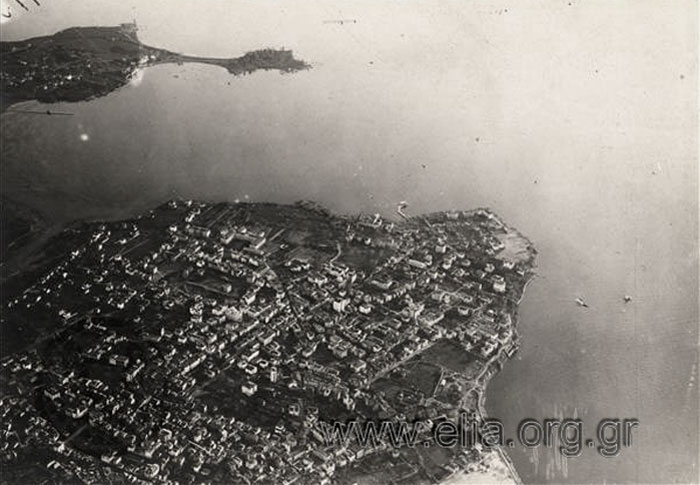 |
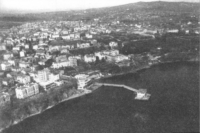
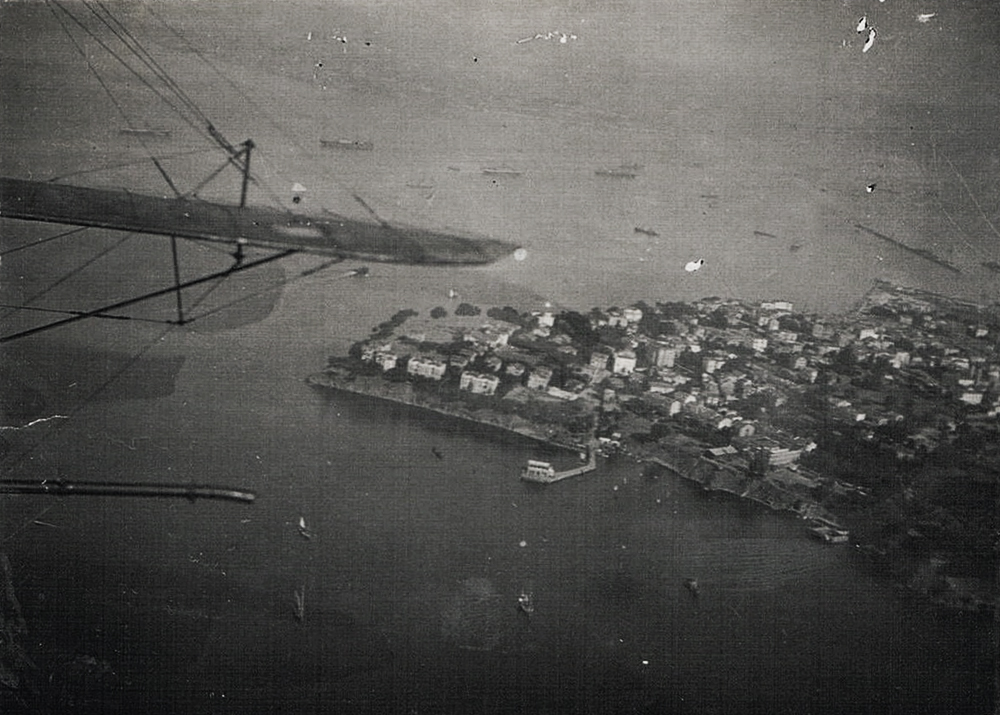
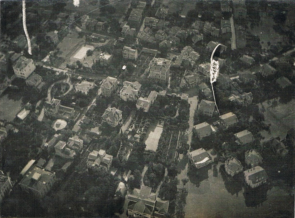
Aerial views of Moda, ca. 1920-23.
 |
 |
 |
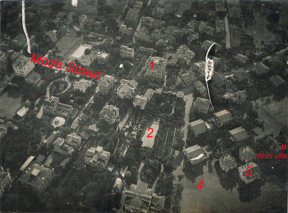 |
Aerial interpretation courtesy of Osman Öndeş
1- Sarıca Arif Paşa Konak, still standing, 2- The park within the Whittall plot, used in the 1960s as a roller skating club, later an open air cinema. 3- Moda caddesi, 4- None of these villas stand today, the empty area still houses the tennis court of the nearby Moda Deniz Club, 5- The villa was pulled down in the 1960s, the plot bought by the Cimcoz family who then built the high rise ‘Salah Apt.’
1- Sarıca Arif Paşa Konak, still standing, 2- The park within the Whittall plot, used in the 1960s as a roller skating club, later an open air cinema. 3- Moda caddesi, 4- None of these villas stand today, the empty area still houses the tennis court of the nearby Moda Deniz Club, 5- The villa was pulled down in the 1960s, the plot bought by the Cimcoz family who then built the high rise ‘Salah Apt.’