
Ephemera
Archive aerial photographs of Smyrna
Aerial photographs are as old as photography and means of lifting of the ground. Those done in the 19th century by balloons were extremely rare and the results usually unsatisfactory. With military necessity with WWI, both airplane and photography technology rapidly advanced and after that war, this was used for uses such as urban planning and civic promotion. In 1920 Smyrna was under Greek occupation, so again with a military motive this clear image was captured and remains in the archives of the Aikaterini Laskaridis Foundation. Yaşar Ürük of Izmir has kindly marked on this map the location of the various landmarks and prominent buildings of the time.
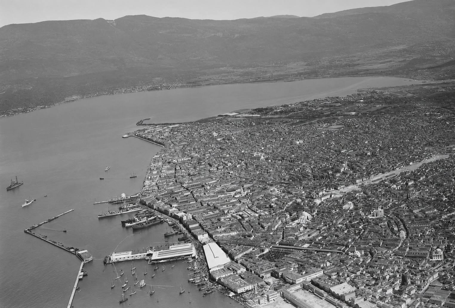
The original photo, looking north from the former Sari Kisla barracks in Konak towards the Punta point and the English railway pier and Bayraklı across the bay.
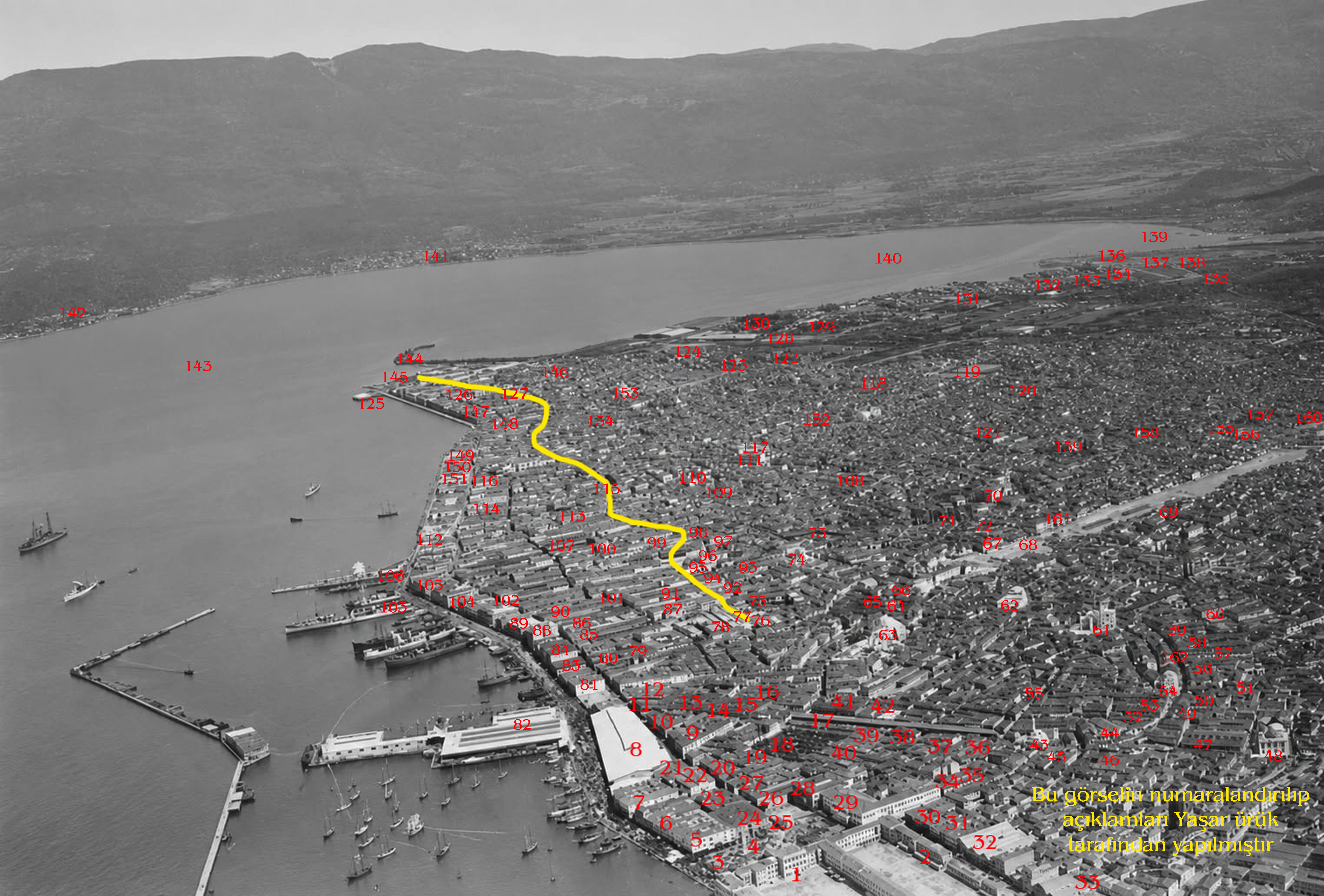
With legends:
1- Sarıkışla barracks
2- Barracks outbuildings
3- Konak Square
4- Clock Tower (AI deformed - deformed by artificial intelligence)
5- Bakırcıyan Han [warehouse]
6- Maksudyan Han
7- Küçük Sadıkbey Han
8- İzmir - Aydın Railway Customs Depot
9- Kançıbanoğlu Han
10- İsmail Efendi and Essayan Hans
11- Süleyman Efendi Han
12- Akkasoğlu Han
13- Guiffray Han (The warehouse where the 1st Turkish Economic Congress will be held later)
14- Daponte Han
15- Uzun Han
16- Pirinç Han
17- Yemiş çarşısı [bazaar]
18- Sulu Cemetery (AI deformed)
19- Balosuloğlu Han
20- Keşişoğlu Han
21- Karantina Han
22- Büyük Sadıkbey Han
23- Halima Han
24- Whittall Han
25- Yalı Mosque (AI distorted)
26- Tabur Efendi Han (AI distorted)
27- Şükrü Bey Han
28- Adliye [Courthouse] (formerly İdadi) building
29- Hükümet [Government] House
30- Evliyazade Han
31- Yusufoğlu Hans
32- Whittall Han
33- Birinci Beyler Street
34- Ragıp Paşa Han
35- Hacı Sadullah Han
36- Kapancıoğlu Han
37- Menekşeli Han
38- Şaphane [building sand wholesaler]
39- Arabi Han
40- Yahya Paşa Han
41- Cezayir Han (AI distorted)
42- Cambaz Han (AI distorted)
43- Ahmet Ağa (Kemeraltı) Mosque (AI distorted)
44- Kemahlı İbrahim Efendi Han (AI distorted)
45- Küçük Barut Han
46- Büyük Barut Han
47- Büyük Salepçioğlu Han
48- Salepçioğlu Han
49- Emirler Han
50- İmam Han
51- Kestelli Caddesi
52- Bey Han
53- Eşref Paşa Han
54- Hacı Hüseyin (Başdurak) Mosque (AI deformed)
55- Ali Paşa Square (AI deformed)
56- Abacıoğlu Han
57- Piyaleoğlu Han
58- Arap Han
59- Küçük Karaosmanoğlu hanı
60- Havra Sokak [Synagogue street] (AI deformed)
61- Kestanepazarı Mosque (AI deformed)
62- Niflizade (Şadırvan) Mosque (AI deformed)
63- Molla Yakup (Hisar) Mosque (AI deformed)
64- Mirkelamoğlu Han
65- Selvili Han
66- Büyük Karaosmanoğlu hanı
67- Çukur Han
68- Bulvar Yolu (A 25-meter wide land area that was opened by demolitions as a result of expropriations carried out by the company established in 1917 to connect Basmane Station and the Customs area. This construction, which stopped during the occupation, was only completed in 1941 and the Fevzipaşa Boulevard was put into service.) (AI deformed)
69- Entrance to Mezarlıkbaşı-İkiçeşmelik road
70- Surp Stepanos (St. Etienne) Armenian Church (AI deformed)
71- Bölükbaşı Mosque and Hamam (AI deformed)
72- Deve hanı
73- Dervişoğlu Han (AI deformed)
74- Aya Yorgi [St George] Orthodox Church (AI deformed)
75- Büyük Vezir Han (AI deformed)
76- Fazıl Ahmed Pasha (Balıkpazarı) Mosque and Balıkpazarı Hamam (AI deformed)
77- Frank Street (the trading thoroughfare indicated by a yellow line. It was two and a half kilometers long. It started in front of the Grand Vizier Han. It passed through the Mahmudiye (Yaladika), Sultaniye, Fasula, Teşrifiye (Trassa) and Mesudiye (Şinadika) sections in order and ended right at Punta Point on the coast. The last section, Masudiye, is today the Kıbrıs Şehitleri Caddesi.
78- Girit Han
79- Osman Kaptan Han
80- Matchela Han
81- Haralambo Yusufoğlu Han
82- Customs buildings (Now Konak Pier)
83- Balyozoğlu Han
84- National Bank of Greece (Now Provincial Directorate of Culture and Tourism)
85- Spartalı Han
86- Sadık Bey Han
87- Spartalı Ferhanesi [warehouse & shops complex]
88- Oriental Carpets carpet company
89- Paterson warehouses
90- Hacı Davut Han
91- Coya Han
92- Küçük Vezir Han
93- Evangeliki School main building
94- Greek Orthodox Metropolitanate
95- Aya Fotini Orthodox Church
96- Aya Fotini Church bell tower
97- Kaymak Paşa Street (Grand Tavernas Street)
98- St. Polycarpe Church
99- Sakız Han
100- Santa Maria Catholic Church
101- Old Fish Market (Sahiliye) Street
102- Parallel (Second Kordon) Avenue
103- Hamidiye Pier
104- Chamber of Commerce building
105- Alexandria Hotel
106- Passport Buildings
107- French Lazarist College (Now Izmir Commercial High School)
108- İspitalya (hospitals) District (Aya Haralambos Greek Hospital, the Catholic Hospital and the Dutch Hospital)
109- Fire Station Tower
110- The St Joseph Freres French High School
111- The St. John the Evangelist Catholic Cathedral
112- Splendid (formerly Kraemer) Palace Hotel
113- The British Consulate
114- The US Consulate
115- Fasula Square
116- La Centrale Italian Girls’ School
117- The Greek Kentrikon Girls’ School (now Atatürk High School)
118- New Evangelical School (now Namık Kemal High School) in construction
119- The Greek Apollon team football field
120- Greek Orthodox Aya Trifon Orthodox Church
121- St. Rocco (Plague) Hospital
122- Reji Tobacco Factory (now İzmir Culture and Arts exhibition centre)
123- St. John the Evangelist Anglican Church
124- Izmir-Aydın Railway Station
125- The Baths of Club Eden (Later Altay Local / Palet Restaurant)
126- Santa Maria del Rosario Catholic Church
127- Mesudiye (Now Kıbrıs Şehitleri) Street
128- The Greek Panionios team football field
129- The Greek Orthodox Cemetery
130- The Gas Factory
131- Darağaç (Gallows district)
132- Mills District
133- Greek Orthodox Aya Markella Church
134- Hacı Andoni Flour Mill
135- Yeşildere Riverbed (They call Yeşildere "Meles". This is absolutely wrong. The real Meles stream is the Bornova Stream due to its proximity to Tepekule, which was Izmir in the Homeric period, and its origin from the slopes of the Homeric Valley).
136- Yeşildere Alluvium/Delta Region (Today, Alsancak Port largely comprises this area, there are loading/unloading facilities forming it).
137- Toll bridge
138- Tuzakoğlu flour factory (Izmir Metropolitan Municipality Vocational Training Factory, which recently caused major problems)
139- The section of the Inner Gulf called the Bornova Gulf. (This area, which once included the Bornova pier, is now within the reclaimed land area)
140- The inner gulf
141- Bayraklı
142- Turan
143- Izmir Gulf
144- Punta (English Pier) (Today, the passenger ferry pier of Alsancak Port)
145- Punta (This name, meaning "end" or "point," is somehow used for the entire Alsancak region. The correct usage should only be for the area where the pier curves in a pointed shape).
146- Bornova Street
147- Spartali Mansion (Today, the Atatürk Museum)
148- Bella Vista (Today, Gündoğdu)
149- Izmir Theatre
150- The French Consulate
151- The Sporting Club
152- Greek Orthodox St. Catherine’s Church
153- Greek Orthodox St. John’s [Aya Yani] Prodromos Church
154- The French Hospital
155- The American Girls’ College
156- The Armenian Girls’ School (Surp Hripsinyants)
157- Greek Orthodox Evangelistria Church
158- The Armenian Hospital
159- Greek Orthodox St. Dimitri Church
160- Meles Cinema (Now Akdeniz Textile building)
161- Büyük Çukur Han
162- Hükümet [Government] Street (Now Anafartalar).
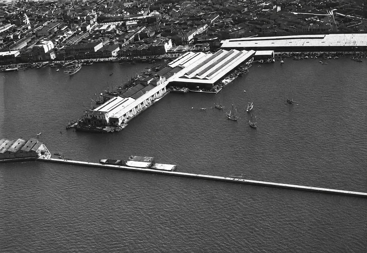
From the same series, close-up of the Custom’s pier as seen in 1920.
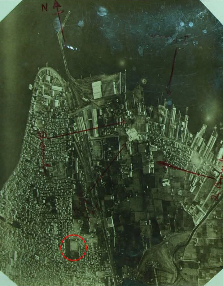
Aerial photograph of Smyrna and Apollon Stadium (marked in the red circle) by RAF in 1917. The 4 arrows point to the early version of post-bombing aerial reconnaisance / analysis. The aiming appears to be for the industrial, railway infrastructure and port zone of Darağacı district, though the damage was slight - sections of the account of these bombing runs on the city can be read in the diary of Grace Williamson.
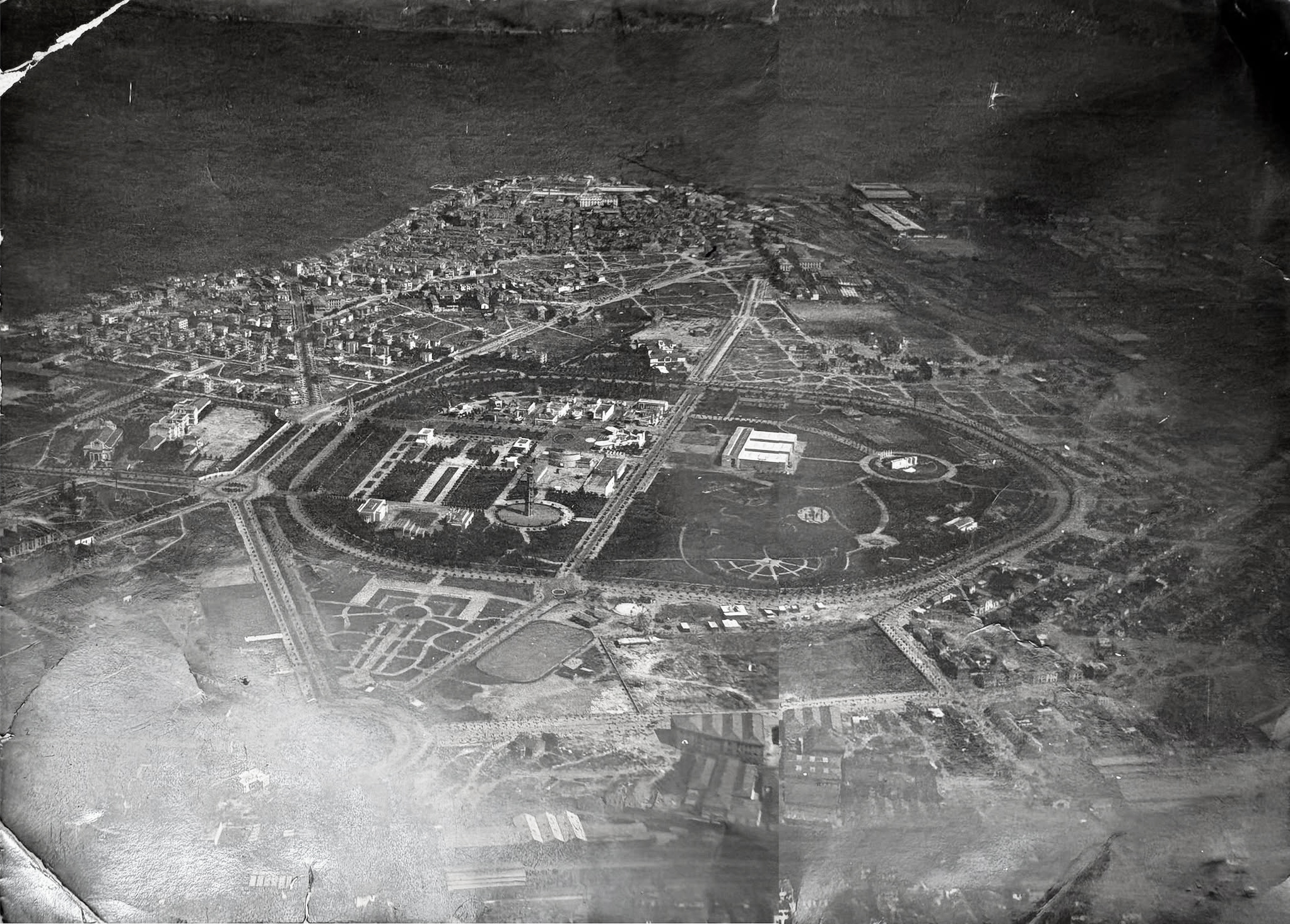
Aerial photograph from 1941 of Izmir post the layout of the Kültürpark [Culture park centered on the former Greek / Armenian quarters destroyed in the 1922 fire]. Kültürpark was founded in 1936 and the empty fields around before the construction boom of the 1950s suggests this was taken sometime between these rough dates. Prominent buildings that survived the fire are visible such as the Catholic cathedral of St John to the left of the image.
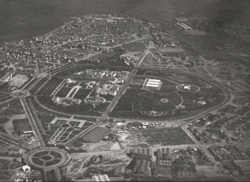
The same photo with a zoom-in with added contrast. Below building identifications courtesy of Yaşar Ürük.

1 - Dokuz Eylül Meydanı, 2- Anafartalar Caddesi, 3- Belediye Mıntıka (todays Konak Belediyesi) building, 4- Süt Çiçeği (todays Sosyal Hizmetler Müdürlüğü) building, 5- Büyük Gazi Bulvarı, 6- 1364. Sokak, 7- 1362. Sokak, 8- Dr. Behçet Uz (todays Hürriyet) Bulvarı, 9- İzmir Yolcu Otobüs bus station, 10- Kültürpark 9 Eylül (Basmane) Gate, 11- Aziz Akyürek (todays Mürselpaşa) Bulvarı, 12- Basmane Gar depo buildings, 13- (Former) Meles Sineması (todays Akdeniz Tekstil) binası, 14- (former) International (American) Koleji city campus, 15- 1264. Sokak (former Meles Caddesi), 16- Bozkurt Caddesi, 17- Etiler Mahallesi, 18- Oğuzlar Mahallesi, 19- 1397. Sokak, 20- Kahramanlar Quarter, 21- 1416. Sokak, 22- Kültürpark (later) Lunapark and area of the construction of its depos, 23- İzmir Atlı Spor Kulübü main (later Fuar / İzmir Radio) building, 24- Atlı Spor Kulübü manege, 25- Doktor Refik Saydam Bulvarı, 26- Şükrü Kaya (todays Şair Eşref) Bulvarı, 27- Kereste depoları [timber yards], 28- Tevfik Rüştü Aras (todays Şehit Nevres) Bulvarı, 29- St. John Cathedral, 30- 1379. (todays Şevket Özçelik) Sokak, 31- Cumhuriyet Kız Enstitüsü building under construction, 32- Vasıf Çınar Bulvarı, 33- İzmir Erkek (todays Atatürk) Lisesi, 34- Montrö Square, 35- Kültürpark Montrö Gate, 36- Lozan Square, 37- Kültürpark Lozan Gate, 38- Kültürpark Vakıflar (Later Pakistan / Hindistan) Pavyonu, 39- Kültürpark Uzun Havuz, 40- Kültürpark Maarif Pavyonu (Later İzmir Arkeoloji Müzesi / Sağlık Pavyonu / İzmir Tarih ve Sanat Müzesi), 41- Kültürpark Paraşüt Kulesi, 42- Kültürpark Şehir Lokali, 43- Kültürpark 26 Ağustos Gate, 44- Kültürpark Büyük Lake, 45- Kültürpark Gül Garden, 46- Kültürpark Open-air Theatre, 47- Kültürpark İzmir Zoo, 48- Kültürpark Cumhuriyet (Kahramanlar) Gate, 49- Mimar Sinan Quarter, 50- İzmir-Aydın railway line, 51- Ege Mahallesi, 52- Umurbey Mahallesi, 53- Darağacı, 54- Alsancak Stadium, 55- Havagazı Factory, 56- Halk (later Altınordu football ground / Atatürk Spor Salonu / todays Voleybol Salonu) football ground, 57- Kâzım Özalp (todays Ziya Gökalp) Bulvarı, 58- Tekel Sigara Factory (todays İzmir Culture and Arts Factory), 59- Alsancak Railway Station, 60- English Pier (todays Alsancak Liman), 61- Alsancak Sea Baths (later Altay lokali, Palet restaurant), 62- Alsancak Pier, 63- İkinci Kordon, 64- Mesudiye (todays Kıbrıs Şehitleri) Caddesi, 65- Alsancak Quarter, 66- Mahmut Esat Bozkurt Caddesi, 67- Celal Bayar (todays Talatpaşa) Bulvarı, 68- French (todays Alsancak Devlet) Hospital, 69- İzmir İkinci Erkek (todays Namık Kemal) Lycee, 70- Doktor Mustafa (todays Mustafa Enver) Bey Caddesi, 71- Nevvar-Salih İşgören Sokak, 72- Voroşilof (Todays Plevne) Bulvarı, 73- Gazi Primary School, 74- Güzelyer (todays Gündoğdu Square), 75- Cumhuriyet Bulvarı, 76- Kültür Quarter.